 The Independent Uganda: You get the Truth we Pay the Price


Studies show expanding cities and vulnerable buildings increase risk
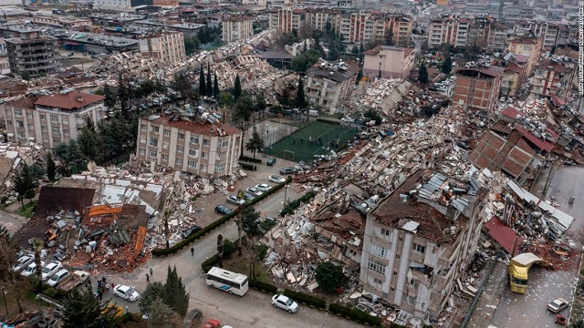
Kampala, Uganda | THE INDEPENDENT | Over 20,000 people were killed following an earthquake in Turkey and Syria on Feb.06, according to multiple reports.
That death toll places it closer to the February 04, 1976 quake in Los Amates, Guatemala, which killed 23,000 and is listed among the top 10 deadliest earthquakes since 1950.
Earthquakes constitute one of the most deadly naturally triggered disasters in the world. The deadliest earthquake on record killed 655,000 people in Tangshan Province in China on July 28, 1976.
The Tangshan earthquake had a magnitude of 7.8 on the Richter scale. The same as the Turkey-Syria quake. Both are not among the most powerful quakes on record. The most powerful quake was a magnitude 9.5 in Bio-Bio, Chile that killed 1,800 on May 22, 1960.
These facts and figures are important to anyone attempting to understand the danger that countries like Uganda and others that lie in earthquake prone areas of the world face.
The Turkey-Syria quake hit a 500km area; that approximately the distance between Arua city in NNW Uganda and Kampala via Masindi.
According to experts, an earthquake can happen in Uganda at any time. They say earthquakes occur in this region all the time. Two days after the Turkey-Syria quake, on Feb.08, a Magnitude 4.7 quake occurred in the Indian Ocean, 47 km East of Tanga, Tanzania. Many earthquakes occur but are too small and are barely noticed by most people. The ground may shake and household items may rattle or tumble down but nothing much.
A big one occurred on September 10, 2016. It measured a magnitude of 5.7 on the Richter scale and struck Uganda and other countries within the Lake Victoria Basin region.
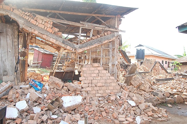
Rakai was the most affected area in Uganda with four people dead and 20 admitted to hospital with injuries. Up to 590 people were affected and numerous houses destroyed.
The earthquake tremor shocks were felt for 20 seconds to 3 minutes across different parts of Uganda, and rippled out as far as Rwanda and western parts of Kenya – which are all parts of the Victoria Basin. Its depth was reported to be only 23 kilometers and this was considerably shallow. On the Modified Mercalli Intensity (MMI) Scale 1, the earthquake measured 7.99, which can either be considered very strong or severe.
The earthquake’s epicenter was located east of the north-western town of Nsunga, – Kagera region in Tanzania on the border of Lake Victoria and it triggered a green Global Disaster Alert Coordination System (GDACS). Following the earthquake’s main-shock, there were lighter aftershocks reported the next day in the affected areas in Tanzania that had been struck by the earthquake.
In Bukoba, Tanzania, 16 people are now known to have lost their lives and 253 injured after the magnitude 5.9 earthquake struck. Homes and business were damaged or destroyed and infrastructure, electricity and communication disrupted and destroyed. A 200-kilometre stretch of road was badly cracked.
In the same year, a magnitude 4.3 earthquake hit Ethiopia. The next year, in 2017, a magnitude 4.7 earthquake hit Hoima in Uganda. A year later a magnitude 5.6 earthquake hit Malawi in 2018 while a magnitude 5.9 earthquake struck Mozambique.
Going farther back, in 2006, a magnitude 7 earthquake struck Mozambique and in 2009, a magnitude 6 earthquake hit Malawi.
Triggers of earthquakes
Earthquakes occur as a result of tectonic plates, the uppermost layer of the earth’s solid shell, colliding. Earthquakes can also result from the sudden energy releases in the earth’s solid shell which create seismic waves that result in the ground shaking.
This is what happened to trigger the 2016 September earthquake in the Lake Victoria region, an area that had little to no recorded big earthquakes.
Records of Uganda’s vulnerability to earthquakes date back to 1897. Over the years, earthquake shocks of varying magnitudes have been recorded in different parts of the country – especially in the Rwenzori Mountains which is one of Uganda’s most seismically active areas.
The Fort-Portal area, which is proximate to the Rwenzori Mountains, records most of the shocks that are felt in Uganda. Other places that have seen significant numbers of shocks between 1910 and 1960 include Mubende , Mbarara , Hoima, Entebbe, Kabale and Kampala. These areas are known epicenters of tremors in Uganda.
Other areas of seismological importance include the Rwenzori mountains which recorded approximately 800 seismic events per month with local magnitude ranging from -0.5 to 5.1 between February 2006 and September 2007.
Tremors vary in magnitude but the most destructive earthquakes so far in the history of Uganda, occurred on March 20, 1966 in the Toro region and on February 05, 1994 in the Kabarole district measuring 6.6 M and 6.2 M respectively.
In the Toro region earthquake, 150 people were killed and 1,300 injured. In 1966 Uganda had a population of 8 million according to records. That is 0.0019% of the population. That is about 940 people based on today’s population of 50 million people, according the United States Data.
In the Kabarole district earthquake 8 people were reported to have been killed together with property destruction estimated at US$ 61 million.
The Victoria Basin is susceptible because it lies between the two branches where the earth’s crust or solid shell are prone to move. This is the East African Rift Valley System (EARVS).
The EARVS which is 6000km long is the world’s largest continental seismic rift system. It extends from the Red Sea/Gulf of Aden near Somali to Malawi in the south. It is formed by the western and eastern rift branches. The eastern branch runs North-to-South from Afar Depression in Ethiopia through Kenya and central Tanzania, several hundred kilometers from the origin of the earthquake.
The western branch runs from Southern Sudan to Western Uganda, Rwanda, Burundi and Tanzania along the boundary with the Democratic Republic of Congo.
According to the United States Geological Survey (USGS), the origin of the 2016 earthquake in Uganda was some 200 km or more from the east and west branches of the EARVS.
Worrying trends
In early July 2013, three moderate earthquakes shook Uganda’s Albertine region in one week as reported by the Integrated Regional Information Networks (IRIN).
The tremors were felt mainly in Kampala, Hoima and Kagadi in midwestern Uganda and in Bunia in the Democratic Republic of the Congo, according to the European-Mediterranean Seismological Centre.
The first of the three quakes – with a magnitude of 5.2 – occurred on the afternoon of July 02, while a second, measuring 5.4, occurred late in the evening on July 03. A third, measuring 5.7 and described by seismologists as “dangerous”, took place at 01:22 am on July 04.
Experts say a quake of 5.7 magnitude is capable of considerable damage, especially in built-up urban areas. However, the IRIN report said the tremors caused little damage but raised concern about quake-prone Uganda’s preparedness in the event of major seismic activity.
“Earthquakes have been there. We live with them. However, this repeated occurrence is worrying. We are going to analyse the phenomena and see why,” said Fred Tugume, the-then principal geophysicist in the Department of Geological Survey and Mines.
“Of course the government doesn’t have the capacity and ability to handle emergencies. We have seen it failing in handling the landslides, fire outbreaks and epidemic outbreaks in the country,” said John Ken Lukyamuzi, then-an opposition legislator.
“If a disaster was to occur now, we have to depend on the equipment and personnel from the military, the police, the Red Cross and the Ministry of Works,” said the late Maj Gen Julius Oketta, then-national coordinator of the Emergency Coordination and Operation Centre in the Office of the Prime minister.
Experts have identified some proactive lessons that the government could work on as far as earthquake risk reduction in Uganda is concerned. These include encouraging earthquake-resistant buildings, safety of essential infrastructure, and proliferation of earthquake early warning systems supported by free global technologies. Post-earthquake interventions include investment in rescue efforts, including safety and psychosocial needs of rescue teams.
The EARVS area has not been subject to high-magnitude earthquakes but even medium-magnitude earthquakes—with a magnitude between 5.0 and 6.0—can cause devastating losses, according to experts.
An expert paper written on the 2016 earthquake says although it was less devastating in terms of injuries and fatalities compared to two previous earthquakes in Uganda, based on the Modified Mercalli Intensity Scale it was still considered to be severe.
According to some reports, preliminary studies have begun to estimate how expanding cities and vulnerable buildings are increasing risk in the Rift Valley. In 1989, a 6.2-magnitude earthquake that struck Malawi killed 10 people and caused $28 million in economic losses. The same event today could kill as many 1,500 people and cause up to $250 million in losses.
Going forward, experts say, practical efforts—national seismic risk zonation, building regulation, and enhanced designs for resilient infrastructure will be more critical than ever in saving lives and improving the living conditions of people whose lives have been, and will be struck by disaster.